#spatial mapping
Explore tagged Tumblr posts
Visit Tumblr Blog
Explore Tumblr blogs with no restrictions, modern design and the best experience.
Last Seen Tumblr Blogs


Fun Fact
Tumblr.com rank in the US is 25.
Text
This week I have been doing Stoned Exposure Therapy which is where I wait for the edible to hit, leave the house, recite the litany against fear ("I must not fear, fear is the mind-killer," &c.), then psych myself into attempting a mundane activity that freaks me out for autism reasons (if avoiding it is impeding how I want to move through the world). Today's Stoned Exposure Therapy was "take a shorter but totally unfamiliar bus route back from the movie theater instead of a familiar bus route that is 35 minutes longer with an extra transfer." I did it and only got lost once 😤
#And now I have that bus route in my back pocket 😤#Three cheers for WEED my good friend WEED#I like to believe I don't really have the rigid thinking part of autism but. That is. Not true at all lol#I am really scared of unfamiliar transit routes bc my directional/spatial orientation is terrible#Worse in the dark#And I get very lost very easily even with Google Maps#I want to get better at navigating the city grid and being able to move around more spontaneously#I can do it in my own neighborhood but not so much elsewhere
40 notes
·
View notes
Video

flickr
Core, Periphery and Semiperiphery : Spatial Drawings #1 by Russell Moreton Via Flickr: russellmoreton.blogspot.com/ russellmoreton.tumblr.com
#Core#1#photography as research#diagram#mappings#landscape#architecture#scaffolding#grids#systems#conductor#image#light#coordinates#practice#agency#russell moreton#photography space spatial turn#visual art#visual fine art#spatial practice#research creation#ecology of experience#useless flickr uploader#civilization and its discontents#luddites and corporatism#flickr
8 notes
·
View notes
Text
man if i had an actual plot structure to use as scaffolding (because i can’t really do slice of life or things like it) i could write so many N and Uzi words that are just the actual practicalities and obstacles (varying in size and some seen, some unforeseen) of an interspecies relationship
#banana.txt#murder drones#esp for the no solver stuff i tend to work with on my way early pilot era fics#like the diet is an obvious one but there’s also other physical needs. behavior. mindset. culture (esp since copper drones actually have-#-the opportunity to develop a culture outside of the oppressive influence of human society’s treatment of them as a whole)#communication in general which can fall under body language but also plain just. DD vocalization an an range outside of WD auditory-#-processor range. and just senses in general#ITS A LOT TO PONDER#for gods sake DDs think movement wise in three dimensions naturally#as opposed to WDs (and humans) as terrestrial entities spatial map/field of movement being laterally compressed
16 notes
·
View notes
Text


More Maps
@blackbloodredpepper mentioned Bob and Linda’s bedroom having two doors and the part my brain that loves architecture went into overdrive got activated and now I’m going to ramble about the apartment under the cut.
TLDR: Bob and Linda’s bedroom could have originally been a dining room and other weirdness about the apartment.
I want to preface this by saying screenshots of the apartment are inconsistent and there are some things that just generally don’t make sense about the building as a whole. Feel free to disagree these are just uninformed opinions of mine.
Bob and Linda’s Room- I suspect this is a converted dining room. This is mostly based on it having two entry doors that are right next to each other. The closet could have originally been a coat or broom closet. One of the door ways is very close to the stairs of the apartment and the other leads to the living room which would both be good entry ways for guests / entertainment. Teddys dining room for example is directly off his living room which also serves as the entry way for the apartment. It’s also close to the extremely small kitchen.
The Kitchen - The kitchen is so small that when guests are invited over (usually for thanksgiving) another table is set up in the living room. Because of inconsistencies between shots it’s hard to say how much space the kitchen table takes up but it is definitely a very inclosed space at the back of the apartment that requires any guests to travel through a hallway and past a bedroom door to get to it. It’s inconvenient for guests. Also that giant table in front of the fire escape seems like a fire hazard.
Tina’s and Gene’s Rooms- If Bob and Linda’s room was a dining room either Gene or Tina’s room would have been intended to be the master bedroom and the other the guest bedroom. Making the apartment initially two bedroom one bath which is much more standard than four bedroom one bath. They are roughly the same size as rooms and both have a closet/ window(s). I would lean towards Tina’s bedroom being the master bedroom because of its position away from the street, it’s being closer to amenities, and it’s proximity to the crawl space. Gene’s bedroom being street facing, over the stairs, and next to the living room leads me to believe it’s a guest space.
Louise’s Room - This is a closet. In fact none of my maps really do it justice as the Mary Poppins bag of a room it really is. Screen shots consistently show her room as being only as wide as the stairs which would also make it only as wide as Gene’s closet, the washing machine closet, AND the restaurant kitchen. (Eventually I’m going to have to make a whole post on how the restaurant kitchen makes no sense in relation to the stairs, so I’ll save that for now) I usually choose to make it bigger than it actually is on maps so all of her things can fit into it which complicates the dimensions of other things particularly the dimensions of the washing machine closet.
I don’t really have any comments at this time on the living room or bathroom that haven’t already been covered above. Overall from behind the scenes materials it does seem like many backgrounds are done on a case by case basis with a few stock staples like the couch and the kitchen which would be why there are inconsistencies. The number of panels in each area isn’t consistent. I’m sure I don’t even need to say that early seasons are especially strange. Sometimes Tina doesn’t have a closet and some electrical sockets moved around.
#bob's burgers#bobs burgers#txt#maps#ramblings#I’m really into spatial things#wait until I make a post about lighthouses#the autism won today
24 notes
·
View notes
Text
I like when books have Maps and Charts in them and I think that all books should have such things.
and books which already have them? I think they should have More Maps and Charts.
#em is posting about temeraire#I do not know Where anything is or Who anyone is or What anything is and hypothetically these things should be explained by the book#but also I would like a Little Help and Visual-Spatial Understanding#what I am wishing for at this time is a Big Fucking Brick of a Book which has Maps and Illustrations and Scale Drawings#which. I do have one of those for the aubreyad and that's how I got informed about ***** ******** ***** ** * ******** ********#so it is not entirely a Good and Fun thing to have one of those#but also I have 'if it's bigger than a horse I can't conceptualize it well' kind of brain which is Hard with both ships and dragons#hey waitaminute I just remembered the fact that my very second piece of Polished aubreyad art (circa 2020) has dragons in it#y'know what lacking this maybe I will try to go back to the Very Scary Bookstore sometime soonishly#and see if they still have that copy of the hornblower companion... hardly anyone goes into that bookstore so I think they very well might#(very nearly everything about that bookstore frightens me but they have really neat stuff there! real copy of porto bello gold!#the hornblower editions with the scratchboard covers! lynd-ward-illustrated master of ballantrae!)
23 notes
·
View notes
Text

MAPPING A LAYER IN A CITY - CAIRO
circles are drawn over a figure-ground map of Cairo - the distance for the call to prayer determined the spatial arrangement of buildings.
_ik
2 notes
·
View notes
Text
It is possible! Thanks to people who did a lot of math! Every projection is a choice of how to represent a sphere on a flat plane and each one prioritises different things. Mercator is excellent for charting courses at sea as it preserves the angle measurements taken on a compass, but at the expense of areas being inaccurate as above.
Equal area projections have to sacrifice something else instead. Generally this means shapes are distorted in some way that preserves area but means it's not useful for navigation like the Lambert Azimuthal projection. Or mean the latitude lines are curved rather than straight like the Eckhert VI map. For others it means that the map is no longer square shaped like the Goode homolosine, dymaxion or the waterman butterfly.
There is of course an xkcd about projections:
Including one specifically mentioning equal area projections
TL;DR you can buy an equal area world map, they're just not as common
In their defence, a lot of it is sand.
40K notes
·
View notes
Text
Location intelligence data
Advintek Geosciences delivers advanced GIS and location intelligence solutions—powered by MapInfo Pro, Spectrum Spatial & Precisely—to drive smarter business decisions across telecom, energy, public safety, conservation, AEC, utilities, and more. Get rich spatial analytics, real-time mapping, e‑invoicing compliance, and expert support. Contact us in Singapore & ASEAN
#dvanced GIS and location intelligence solutions—powered by MapInfo Pro#Spectrum Spatial & Precisely—to drive smarter business decisions across telecom#energy#public safety#conservation#AEC#utilities#and more. Get rich spatial analytics#real-time mapping#e‑invoicing compliance#and expert support. Contact us in Singapore & ASEAN.">#<meta name=“keywords” content=“Advintek Geosciences#GIS solutions Singapore#location intelligence#MapInfo Pro#Spectrum Spatial#Precisely partner#geospatial analytics#telecom GIS#energy GIS#public safety GIS#conservation GIS#AEC GIS#utilities mapping#e-invoicing
0 notes
Text
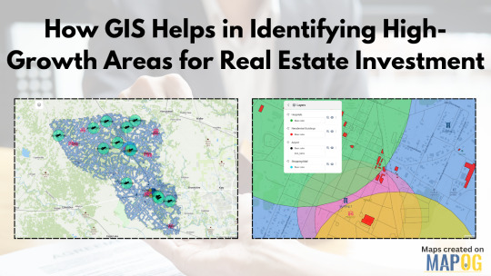
How GIS Helps in Identifying High-Growth Areas for Real Estate Investment
In an ever-changing real estate landscape, identifying areas poised for rapid development isn't just a competitive advantage—it's a necessity. Traditional methods of forecasting growth often fall short in addressing the complex interplays of infrastructure, demographics, and access to essential amenities. That's where Geographic Information Systems (GIS) step in as a transformative force.
GIS as the Eye Behind Data-Driven Real Estate
GIS technology allows users to visualize and analyze layers of geographic and statistical data all in one view. From traffic congestion and transportation routes to proximity to hospitals, schools, malls, and airports—all of this can be layered spatially to make more informed investment decisions. For real estate developers, this is more than just data; it's a dynamic decision-making tool.
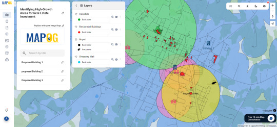
By using GIS, stakeholders can map out locations with strategic access to critical infrastructure. Suppose you're analyzing a city for future residential projects. You could create buffers around public transit lines, shopping centers, and educational institutions to isolate high-potential zones. These buffers offer clarity where raw data often fails to paint the full picture.
Solving the Real Estate Guesswork
One of the biggest pain points in real estate is uncertainty: will a particular neighborhood rise in value? Will upcoming infrastructure really influence demand? GIS helps answer those questions by showing not just what exists, but how it interacts across space and time. For instance, you could track development permits over time or visualize environmental constraints like flood zones or green cover. These insights are crucial for mitigating risk and spotting overlooked opportunities.
Industries like urban planning, government housing departments, logistics, and commercial development firms increasingly rely on GIS to plan smarter. Even small-scale investors are catching on, thanks to platforms that simplify GIS applications into more user-friendly formats.
One Platform, Many Possibilities
Some mapping tools now let you not only import transportation and amenities data but also define your area of interest, set proximity buffers, and drop pins for future projects. You can even share interactive maps with teams or stakeholders. One such example is a GIS platform like MAPOG, which simplifies the entire GIS workflow from analysis to visualization without needing deep technical skills.
Whether you're evaluating urban corridors for commercial hubs or scoping out suburban areas for housing, GIS offers the clarity you need. Try exploring platforms like MAPOG if you're looking for a seamless way to start.
#realestateinvestment#gis#mapog#gismapping#smartcities#urban planning#urban growth#mapping#data visualization#spatial analysis#propertydevelopment
0 notes
Video
flickr
Core, Periphery and Semiperiphery : Spatial Drawings #1 by Russell Moreton Via Flickr: russellmoreton.blogspot.com/ russellmoreton.tumblr.com
#Core#1#photography as research#diagram#mappings#landscape#architecture#scaffolding#grids#systems#conductor#image#light#coordinates#practice#agency#russell moreton#photography space spatial turn#visual art#visual fine art#spatial practice#research creation#ecology of experience#useless flickr uploader#civilization and its discontents#luddites and corporatism#flickr
2 notes
·
View notes
Text

Advance your career with IGMPI’s industry-oriented PG Diploma in Geoinformatics. Learn GIS, remote sensing, spatial data analysis & more. Enroll online today!
Enroll in the Post Graduate Diploma in Geoinformatics offered by IGMPI – a government-recognized institute. This distance learning course provides in-depth knowledge of GIS, remote sensing, spatial data analysis, and practical tools used in geosciences and urban planning. Ideal for professionals in geography, environmental science, agriculture, and infrastructure sectors.
#Geoinformatics course India#PG Diploma in Geoinformatics#GIS course online#IGMPI Geoinformatics program#remote sensing training#spatial data analysis course#GIS distance learning#Geoinformatics certification India#GIS and mapping course#online Geoinformatics diploma
0 notes
Text


#Diaspora connections#abstract cartography#African diaspora#migration patterns#visual storytelling#cultural mapping#Afro-futurism#ancestral roots#global Black identity#geographic abstraction#identity exploration#Black history#transatlantic heritage#artistic maps#abstract design#cultural networks#historical displacement#African legacy#creative mapping#symbolic landscapes#memory and movement#ancestral pathways#Black cartographers#visual narrative#global unity#borderless art#spatial identity#heritage mapping#Black migration#interconnected histories
1 note
·
View note
Text
Mastering QGIS Desktop 3.34 LTR: From Beginner to Pro.
English Video tutorial, just for $9.99 (NORMAL price $19.9). Get it once and you will get endless access right.
Unlock the full potential of QGIS Desktop 3.34 LTR! This comprehensive guide takes you from the basics to advanced spatial analysis, helping you master GIS techniques, data visualization, and automation with Python. Whether you're a beginner or an experienced user, this book will elevate your GIS skills.
#QGIS 3.34#QGIS tutorial#GIS software#spatial analysis#QGIS Python#mapping software#open-source GIS#QGIS for beginners
0 notes
Text


us and our partner sprinted for 19 minutes to find this azelf the other day :'3 you get to see both of ours because it even has the fact that we were in a party on its info!!! :'D
#pokemon go#azelf#literally caught it the MINUTE before it was supposed to despawn#and ONLY caught it because our partner remembered we both have palkia's spatial rift#but it evens out because azelf only showed up on OUR map#so by our powers combined... lake spirit acquired B3#(( rai 👹 he ))
0 notes
Text
Data survey lapangan dalam UTM dapat di kelola dengan baik menggunakan QGIS.
Data tabular survey lapangan yang di lengkapi dengan titik koordinat UTM zone 47 N dapat di plot ke atas aplikasi QGIS dimana sebaran data ini akan tampil dan memudahkan dalam analisis spasial, pemodelan spasial dan pengambilan keputusan. Dapatkan video tutorialnya disini:
#attribute query#select by attribute#feature info#opensource#gis operator#geodatabase#spatial query#select by location#location allocation#location intelligence#location based services#gis#geoserver#arcgis#esri#openlayers#wms#wfs#web mapping#leaflet#shapefile#qgis#geonode#freelancer#gis analyst#gis jobs#webgis#development#gis professional#project management
0 notes
Text
why am i such an absolute bitch in my dreams hello???? 😭 i ended up getting the summer school dream early and had like 3 angry breakdowns back to back lmao
#minxiety#every year close to the end of school i have summer school dreams#they’re usually really nice aside from the plot being something like#getting lost or not being registered to begin with#but this one SUCKED. a big bonus they had was being cool architecturally#when i was younger i didn’t have a good spatial map of my high school#so the dream school was very quirked up. EXTREMELY interesting#but now that i’ve been to the real place for quite a while.. i was literally just in the regular school..#NOOO!!!! BRING BACK THE INTERESTING CORRIDORS!!!#BRING BACK THE PRIMARILY SUNLIT THIRD FLOOR!!!!!!
1 note
·
View note